 Thanks for connecting!


Pragya Sharma
9 min read
August 9, 2023


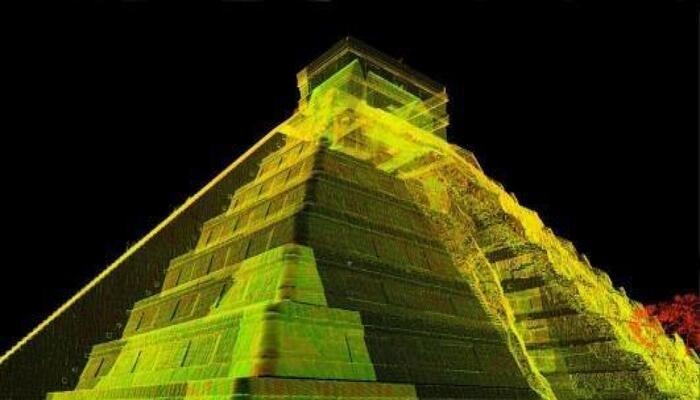
Table of Contents

Heritage structures are an integral part of the modern world. They serve as connecting bridges between the past and present, depicting the journey of human civilization through the ages. The architectural physicality, materiality, and accessibility of every heritage building narrate a story about the geo-political, socio-cultural, and economic conditions of the era in which it was built. Therefore, heritage documentation, conservation, and restoration are imperative for us to learn from the failures and successes of the past to create a formidable future.
What is Heritage Documentation?
Through documentation, the intent is to find, interpret, and preserve historical data for future generations. In the context of the built environment, documentation refers to the process of systematically capturing, recording, and preserving data on heritage sites and buildings. The information is collected in various forms such as written reports, photographs, drawings, and digital models to document the physical, historical, and cultural aspects of the heritage structure.
Documentation works are usually undertaken by a team of historians, conservation architects, research organizations, and local government authorities
How are Heritage Structures Documented?
3D laser scanning in construction industry is primarily used to document buildings that are either massive in scale, inaccessible, dilapidated, or heritage structures. Mentioned below are the key ways in which 3D laser scanning for heritage buildings has evolved over the years:
1. Conventional Heritage Documentation
Traditionally, the documentation of heritage structures was a labor-intensive and lengthy task requiring skilled professionals and meticulous planning. Buildings were manually documented using equipment such as measuring tapes and rulers, level and plumb line, assisted lights, cameras and sketchbooks for hand drawing. Additionally written documentation and historic research helped in understanding the structures better.
2. Photogrammetry
The late 1990’s and early 2000s witnessed a rise in digitalization across the globe. In this light, photogrammetry gained prominence as a technique for historic documentation. Photogrammetry utilizes a method of overlapping photographs to create highly accurate 3D models of heritage structures. By capturing multiple images from different angles, specialized software stitches them together, reconstructing the structure in a virtual environment. This technology allows for virtual exploration, precise measurements, and in-depth analysis of the heritage structure. Moreover, it facilitates the creation of immersive experiences, enabling virtual tours that can be accessed by a wide audience for educational and research purposes.
3. 3D Laser Scanning of Buildings
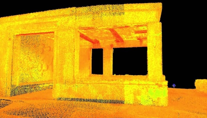
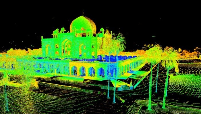
In recent times, 3D laser scanning for heritage structures has presented itself as a promising tool for the purpose of heritage documentation. If you are thinking about what is 3D laser scanning, it employs laser beams to create highly detailed and accurate visual representations of heritage structures. This technology captures millions of data points by measuring the distance between the scanner and the structure's surfaces.
These data points are then used to generate a comprehensive 3D point cloud, creating a digital replica of the heritage structure. Laser scanning enables architects, conservators, and researchers to study the structure from every angle, capturing intricate details, and even detecting minute changes over time. This method provides an excellent level of precision, aiding in restoration planning, structural analysis, and preservation efforts.
Which 3D Laser Scanners Are Used for Heritage Documentation?
Various types of 3D laser scanners are available in the market and professionals can choose the one that best suits their heritage site, context, and structure. FARO Technologies, Artec 3D, and Q- PLUS Labs are some leading 3D laser scanner manufacturers also developing products for heritage preservation.
Let’s have a look at 3 fundamental types of laser scanners helpful for heritage documentation.
1. Triangulation-Based Laser Scanners
Triangulation-based laser scanners project a pattern of light onto the object or surface being scanned and use cameras to capture the deformation of the pattern. By analyzing the deformation, the scanner calculates the 3D coordinates of the points on the surface. Triangulation-based scanners are effective at capturing fine details and textures, making them suitable for documenting intricate architectural elements, carvings, and ornamental features of heritage structures.
2. Time of Flight-Based Laser Scanners
Time of flight (TOF) laser scanners, also referred to as pulse-based scanners, are commonly employed in heritage documentation due to their ability to cover large areas efficiently. These scanners emit laser pulses and measure the time it takes for the pulse to travel to the object and back. This data is used to calculate the distance and create a 3D representation of the structure. TOF scanners effectively capture the overall geometry and dimensions of heritage sites, including facades, interiors, and landscapes.
3. Phase Difference-Based Laser Scanners
Phase difference-based laser scanners utilize the interference of laser beams to measure distances. These scanners emit laser beams with different phases and analyze the phase differences in the reflected beams to calculate distances. Phase difference-based scanners offer high accuracy and are suitable for capturing intricate details and precise measurements. They are often used in 3D laser scanning for heritage documentation projects for analyzing the condition of fragile or complex architectural elements, such as delicate sculptures or decorative elements.
Read: The Powerful Influence of Colonization in India: History and Architecture
The Process of 3D Laser Scanning for Heritage Documentation
Heritage documentation involves strategic planning and understanding of the structure and the time in which it was built. Here is a step-by-step guide to how 3D laser scanning for heritage structures is undertaken:
1. Planning and Preparation
The process begins with careful planning and preparation. The scanning team assesses the heritage structure, identifies the areas of interest, and determines the optimal scanning positions to capture comprehensive data. It is crucial to consider factors such as lighting conditions, accessibility, and safety measures during this phase.
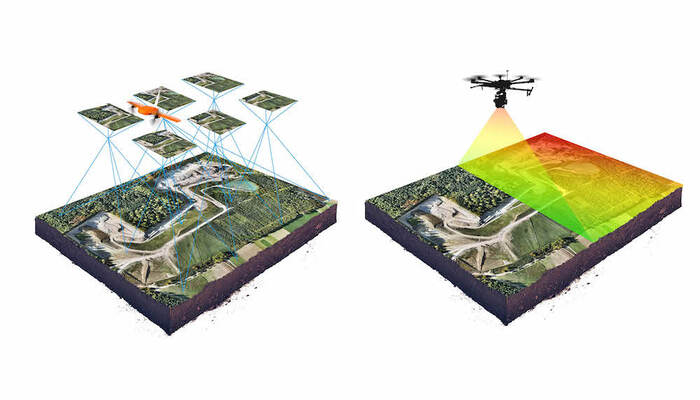
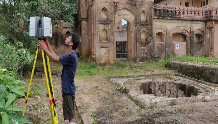
2. Scanning the Structure
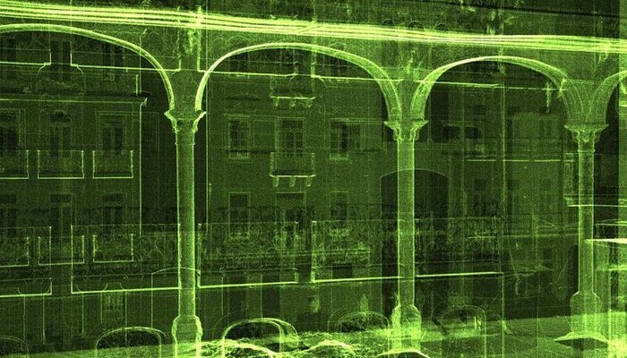
Once the planning phase is complete, the actual 3D laser scanning process begins. The laser scanner, positioned at different vantage points, emits laser beams that sweep across the heritage structure's surfaces. As the laser strikes the surfaces, it measures the distance and records millions of data points, creating a dense point cloud that represents the structure's geometry in three dimensions. Multiple scans from different angles are taken to ensure complete coverage and capture intricate details.
3. Data Processing and Registration
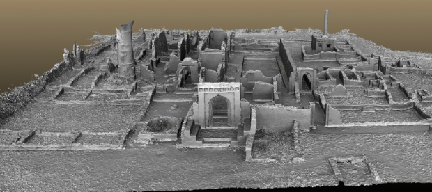
After the 3D laser scanning for heritage building is complete, the captured data needs to be processed and registered to create a coherent and accurate representation of the heritage structure. Specialized software is used to align and merge the individual scans, eliminating any discrepancies or misalignments. This process, known as registration, ensures a seamless and accurate 3D model of the entire structure.
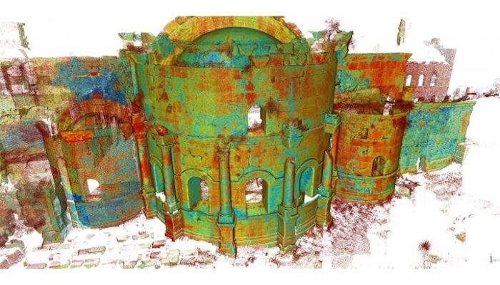
4. Creating the 3D Model
Once the data is registered, it is transformed into a 3D model. The software processes the point cloud, reconstructing the surfaces and creating a digital representation of the heritage structure. This model can be viewed and explored from various angles, enabling a virtual walkthrough of the site and providing an immersive experience for researchers, historians, and the public.

5. Analysis and Documentation
The 3D model generated through laser scanning serves as a valuable resource for analysis and documentation. Architects, conservationists, and researchers can study the model in detail, examining architectural features, identifying areas of deterioration or damage, and assessing structural integrity. Precise measurements can be taken directly from the model, aiding in restoration planning, conservation efforts, and historical research.
6. Archiving and Accessibility
Once the analysis and documentation are complete, the digital 3D model is archived for future reference and accessibility. This ensures that the information captured through 3D laser scanning for heritage structures is preserved and can be accessed by future generations for research, education, and conservation purposes. The archived data can be shared with institutions, museums, and the public, promoting a wider understanding and appreciation of our architectural heritage.
Benefits of 3D Laser Scanning for Heritage Documentation
The process of 3D laser scanning for heritage buildings is rethinking the way we record, analyze, and conserve built legacy. Let’s have a look at how they are benefiting the heritage documentation process.
1. High Accuracy and Detail
Laser scanners emit laser beams that measure millions of data points, creating a dense point cloud representing the structure in three dimensions. This level of detail achieved through 3D laser scanning of buildings allow for precise measurements, capturing intricate architectural elements, decorative features, and surface textures that might be missed by traditional documentation methods. The resulting 3D model provides a complete and accurate record of the structure, aiding in preservation, restoration, and research endeavors.
2. Time and Cost Efficiency
Manual documentation requires substantial resources, labor-intensive fieldwork, and lengthy data processing. On the other hand, the process of 3D laser scanning of buildings can capture vast amounts of data covering large areas in a fraction of the time. Moreover, the digital nature of the data allows for efficient post-processing, eliminating the need for extensive manual data manipulation. This increased efficiency translates into reduced project timelines and costs, enabling more comprehensive and timely heritage documentation efforts.
3. Non-Invasive and Non-Destructive
Unlike invasive methods that may require physical contact or sampling, 3D laser scanning is a non-invasive and non-destructive technique. Scanners can capture data from a distance ranging from 50 meters to 1 kilometer without causing any harm or altering the structure. This aspect is particularly critical for fragile or vulnerable heritage sites, ensuring their preservation and minimizing the risk of damage during the documentation process.
4. Enhanced Visualization and Analysis
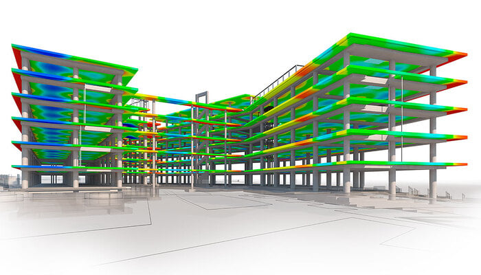
The digital 3D models generated from laser scanning offer enhanced visualization and analysis capabilities. These models can be viewed, explored, and manipulated from various angles, providing conservation architects with a virtual walkthrough of the heritage site. The use of advanced BIM- integrated software tools enables detailed analysis, such as measurements, cross-sections, and comparisons. This helps in understanding the architectural features, identifying areas of damage, and informing conservation and restoration decisions.
5. Documentation of Inaccessible Areas
Heritage structures often contain inaccessible or hard-to-reach areas that pose challenges for traditional documentation methods. 3D laser scanning provides a solution by capturing data remotely, allowing for the documentation of intricate architectural details, hidden spaces, or high elevations that would otherwise be difficult to access. This comprehensive documentation ensures that no aspect of the heritage structure is left undocumented.
Read: The Definitive Guide to Digital Fabrication: All You Need To Know About This Digital Wonder
Case In Point
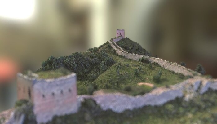
The Great Wall of China is an ancient architectural marvel that spans over 13,000 miles (21,196 kilometers) across northern China. A UNESCO World Heritage site, it is one of the most iconic and historically significant structures in the world. While the Great Wall of China as a whole is a vast and complex structure, certain sections of the wall have been the subject of 3D laser scanning initiatives.
The use of 3D laser scanning for heritage documentation enabled the accurate data collection and representation of the wall's architectural details, including the construction techniques, dimensions, and variations in structure along different sections. This comprehensive documentation helped in understanding the evolution of the wall and its historical significance.
Additionally, 3D laser scanning helped identify areas of deterioration, damage, or structural instability along the wall. By capturing precise measurements and data, the technology enables conservation architects to assess the condition of the wall, determine potential risks, and plan appropriate preservation and restoration strategies.
In Conclusion
Heritage documentation and preservation play a crucial role in safeguarding our diverse cultural heritage, supporting the protection of valuable assets, and promoting a deeper understanding and appreciation of our shared history and identity. Therefore, the modern world must be more involved and driven towards protecting and conserving heritage structures for which, the 3D laser scanning technology can be of immense help.
Conducting heritage walks and interactive education programmes could immensely help in igniting heritage curiosity amongst young minds. This would in turn help in curating a responsible society that preserves and acknowledges its built heritage.
If you are a budding conservation architect or simply interested in history and 3D laser scanning for heritage buildings, you must check out BIM Professional Course offered by Novatr. By enrolling for the course, you can master 7+ BIM software and industry workflows, learn from industry stalwarts, and work on a capstone project to hone your skills. Explore the course today.

.png)

.png)

.jpg)